Cape Town decided way back in 2004 that it needed to do something about the burgeoning traffic loads on our roads. A number of reasons
for the increased traffic loads exist.
Trains in the past carried most of our freight between the larger centres. Due to the deterioration in the railway systems over the
past few years road transport has become more widely used and hence we today have thousands of large trucks carrying freight to all
parts of the country on our roads.
A second problem started around 1990 when people from all over South Africa and the rest of Africa identified the city as
a place to find work and arrived in droves and settled on the Cape Flats where there was no housing, very little infrastructure
and no reliable public transport to get them to work.
Someone saw the transport gap in the market and the mini bus taxi industry was born.
Over the years the minibus taxi industry has grown out of its seams and there are today thousands of these minibus taxis
on our roads. To make matters worse these drivers are a law unto themselves and do not heed traffic lights, overload vehicles
and don't mind stopping in the middle of a busy road or intersection to pick up passengers. Of course speed limits and traffic
signs are there to be ignored as are red traffic lights.
In an effort to bring some order back onto the roads and to clear some of the congestion caused by all the extra traffic
the IRT system (integrated rapid transport system) was decided upon.
The objective of implementing the system is to get cars off our roads and to get people to use public transport.
The IRT system.
The aim of introducing Cape Town Integrated Rapid Transit System is to transform the public transport sector in the city and
improve the public's experience. The IRT plan will eventually integrate all modes of transport such as the Metrorail services,
road-based services on less important routes, bus services, minibus taxis, feeder bus services, improved pedestrian and bicycle access,
metered taxi integration, and park-and-ride facilities.
The way the system will be introduced into Cape Town is by using a transport system known as the BRT or Bus Rapid Transport system.
The BRT system will be quick, comfortable, cost effective and have frequent operations along the dedicated routes they will follow.
The idea is to provide excellent customer service which will cost less than using a car into the city and which will eventually persuade
Cape Town's motorists to use public transport instead of their cars.
By reducing the numbers of cars on our roads we will also reduce the carbon footprint of our city.
So how is this BRT system being implemented?

A completed section of the bus lane coloured red to the left of the cars.
The bus lanes between Paddocks from where this photo is taken is more or less complete with just a few finishing touches needed.
Dedicated bus lanes will provide the public with drastically reduced travel times as the buses will be able to move quickly during
peak hours without the problems of having to negotiate traffic blockages caused by accidents and just too many cars on our roads.
Motorists sitting in their cars watching the buses whisk past them while they are stuck in a traffic jam will soon get the message
that they can save a lot of time and money and frustration by using the BRT system.
Because the buses will be running in dedicated lanes they will use fuel more efficiently which will bring about a large saving and therefore
reduce the bus fares to the public.
Construction ot he BRT lanes.

The bus lanes still have to be completed from near Zastron road to Paarden Eiland
A number of routes have been planned and construction is underway on them.
The route between the Bayside Mall near Table View and the city is going along at pace and should be completed by the time the World Cup is played
in the city. This was one of the laid down conditions of getting the World Cup in Cape Town. The route runs through Woodstock, Paarden Eiland and
across the Salt River canal before it links to the R27 and heads north.
The next phase of this route will include areas such Du Noon, Atlantis and Mamre on the West Coast and will be built after the world cup.
Construction work includes a dedicated lane for cyclists.
Bus Stations

Bus station at Zastron Road still to be completed
Bus stations along the 16km west coast route will have surveillance cameras, electronic information boards and security guards protecting them.
The surveillance cameras along the route will be monitored at a control room based in Goodwood.
The buses to be used in the BRT system have been ordered from Volvo by the City of Cape Town and will start arriving in March 2010
in time to train drivers who have to be ready for the World Cup.
Possible problems.
With the amount of work still to be done on the bus lanes will the work be finished by kickoff for the World Cup?
A drive along the route from Bayside to Milnerton today revealed that most of the bus lanes have been completed although there
is still work to do on the stations and at intersections.
All the bus stations along the route are in the centre of the Otto du Plessis Drive which is a double carriage highway.
How are people going to get to the bus stations without being knocked over especially during peak hour traffic periods?
As most of the bus stations are situated at busy intersections I imagine that access to the stations will be controlled by
pedestrian crossings at the traffic lights. Will traffic adhere to the lights and allow pedestrians to cross?
On the other hand will pedestrians wait for the lights to change or will they jaywalk across the busy highway to catch a bus.
Some of the stations, for example the one at the intersection of Zastron Road and the Otto du Plessis Drive at present do not
have traffic lights. Are they going to install lights at these intersections?
As the BRT system at present is limited to the Otto du Plessis Drive there is no way for people to use public transport to get to the bus stations
other than to use private cars.
There is no parking for those who are willing to drive to a bus station along the Otto du Plessis and catch a bus into town.
Until parking near the stations is provided or feeder transport is introduced from the suburbs around Milnerton very few locals will
be able to use the transport system.
Will Cape Town's new bus lanes be ready for the world cup? The answer to that question should have been yes and no. The MyCiti bus route through the city and
stadium and the route to the airport had to be ready by the time the world cup started. The west coast route would only be completed after the world cup.
Every couple of weeks I drove the bus routes to see what progress had been made and below are some of the photos.

Bus station at Paddocks still to be completed

Bus station and road in Paarden Eiland still to be completed

Bus lanes near Boundary Road still have to be concreted

The completed bus lanes between Boundary Road and Milner Road in Paarden Eiland
A few weeks later I once again took to the streets this time to find out where the bus route went to after the Boundary Road station
and also to see what was finished and what was not.
This is what I found.
Driving from Boundary Road over the railway bridge travelling towards Cape Town along Marine Drive.
The station at Boundary road was not yet complete The BRT lanes on the railway bridge were not complete.
Once over the railway bridge the red concrete lanes are all in place and are being planted up with foliage to beautify the area.

The intersection at Milner Road where the bus lanes turn into Paarden Eiland
The intersection at Milner Road in Paarden Eiland is where the BRT lanes leave Marine Drive and make their way into Paarden Eiland.
If the construction of the BRT Lanes from Bayside Mall in Table View were to end at Milner road and be completed it would make a major difference
to traffic along the Marine Drive and into town.
Construction through Paarden Eiland could continue in the backstreets out of our visitor's view.
This however might not be necessary as most of the construction of the roads for the buses in Paarden Eiland is more or less complete.

The more or less completed bridge over the Salt River Canal
The bridge over Salt River canal is also nearing completion. Stations through Paarden Eiland are mainly incomplete and need finishing touches
to finalise their construction.
Driving along the N1 into Cape Town I could not find where the BRT lanes crossed the N1 and also could not find them in the harbour
area so I decided to follow the construction of the BRT lanes through Paarden Eiland all the way to the N1 to find out the secret.

The old Railway Bridge under the N1 with Table Mountain in the background
I was most surprised at what I found.
In the past there had been a railway line running through Paarden Eiland and the BRT lanes have been built where the line used to run.
The secret of how the BRT lanes crossed the N1 was solved when I found the small tunnel under the N1 which was previously used by trains
to get into the city.
I am not going to pursue this bus lane any longer except to say that it will work its way through Woodstaock and Salt River and join up with
the Eastern Boulevard where it enters the city near the Civic Centre and Artscape on the Foreshore.
I would like to take my hat off to Cape Town motorists for putting up with all the delays, detours and traffic jams that they have faced during
the construction of this bus lane.
When its complete in a month or two it would all have been worthwhile.
The world cup came and went and work on the west Coast bus routes continued. Everyone thought that once the lanes were completed the buses would start running. Unfortunately this was not to be.
Eventually after many months of waiting the buses started to roll.

Tableview station where the morning commute begins
Yes! The wheels on the IRT MyCiti buses are finalling turning and rolling all over town.
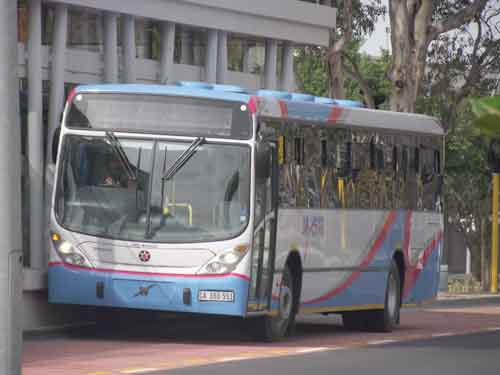
MyCiti bus docking at a station
The West Coast service finally came into operation on the 9th of May 2011 after negotiations
with the Vehicle Operator Companies (VOCs) were finalised and contracts signed as late as the 8th of May.

Route Map between Table View and the Civic Centre in Cape Town
The west coast service started running on the 9th of May with an express service running from Table View station to the
Civic Centre station in Cape Town for the first week.
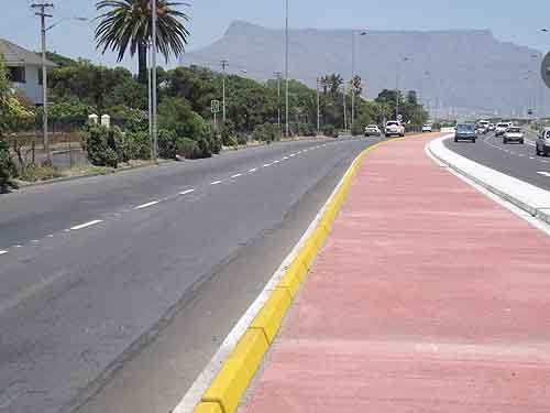
The dedicated bus lane with Table Mountain in the background
Feed back from commuters using the buses is good and it seems that once the buses start stopping at all stations along the
route its popularity will increase even further. What is good about this service is that firstly it is safe. Secondly it runs on time.
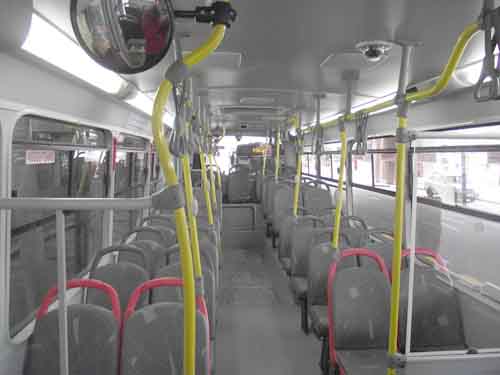
The inside of a MyCiti bus"
On week days the MyCiti buses are scheduled to leave Table View and the City every 20 minutes between 5.45am and 6.30 am, between 6.30am and 9.00 am (peak times) every 10 minutes, and from 9.00am to 15.30pm every 20 minutes. The afternoon peak times start at around 15.30pm and the buses will run every 10 minutes from 15.30pm until 18.00pm. After 18.00pm the buses will revert to every 20 minutes until 22.00pm every night.
On Saturdays the service will run every 20 minutes from 6.45am till 22.00 pm.
On Sundays and Public Holidays the service will begin at 7.45am and run every 20 minutes until 22.00pm.
The cost of a one way trip from Table View to the city will cost R10.00.
With petrol prices having skyrocketed to R10.00 a litre motorists will be saving a fortune on their fuel bills and also parking in the city.
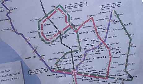
Map of Tableview feeder routes"
For those people living in Parklands, Table View Blouberg and Big Bay a feeder bus service came into operation this past weekend with a
slightly different schedule to that of the main service into the city.
From 5.45 am to 6.30am the buses will run every 20 minutes.. From 6.30am till 9.00am every 15 minutes. From 9.00am till 15.30pm every 15 minutes.
From 15.30 to 18.00pm every 15 minutes. After 18.00pm buses will run every 20 minutes till 22.00pm.
In the Parklands, Table View, Blouberg and Big Bay area 120 bus stops have been set up many of which are outside shopping centres,
schools and housing estates. This will allow people wanting to use the buses to only have to walk a short distances to find a bus stop.
The feeder bus service will take you to the main bus station in Table View where you can catch the bus into the city.
This is going to be a boon for party goers and especially business people who have to attend early evening meetings and events.
With the clamping down by traffic authorities on people driving under the influence people will now be able to have their drinks
and then catch the buses without having to drive home under the influence.

Map of the Inner City/Foreshore route
MyCiti has simultaneously reintroduced the inner city bus service which runs through the central city area before either going up Long
Street or down Loop street to the new Green Point stadium and into the V & A Waterfront before returning to he Civic Centre station
in Hertzog Boulevard.
The cost of this service is R5.00.

MyCiti bus station at the airport
The airport bus service is runs between the city and the airport starting at 4.20am and departing every 20minutes till 21.00pm each evening.
The return trip from the airport to the city starts at 5.10am and runs every 20 minutes with the last bus leaving at 21.50pm. The cost of this
service is R50.00 in one direction.
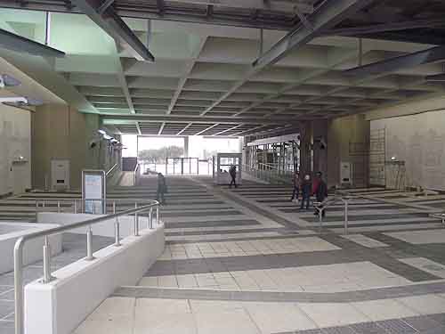
The inside of the Civic Centre bus station
Using the buses to and from the airport could mean a large saving as taxis and tour operators charge exhorbitant prices to do this service for you.
There will also be a saving in parking fees at the airport if you use the buses.
Another benefit of the buses is that they are wheel chair friendly and can accommodate two wheelchairs at a time. People with bicycles can also take
them on the buses if they want to cycle home in the evening.

MyCiti bus arriving at the Civic Centre station
This new bus service has been a long time coming and is going to go along way to alleviate travel problems for the commuters in the Table View area. Instead of getting to work stressed out from the traffic delays due to accidents, broken traffic lights and taxis forcing their way through the traffic, sit back and relax on the bus while watching the less fortunate drivers in their cars having problems.
The service is going to be rolled out even further and construction will be starting soon in the city on the new Green Point Sea Point routes.
Update 15.5.2012
Construction of the bus lanes from Table View northwards towards Atlantis is going on at pace. The buses from Table Bay to the city are being well utilised on the existing route
and the introduction of the service has been a great success. Its strange that even criminals have found this route to be lucrative as they have used it and been caught trying to smuggle drugs.
Planning is going ahead for the bus routes into the Southern suburbs.
The bus routes safety records so far have been pretty good although there have been one or two mishaps.
